With a stated commitment to ‘Place, Politics and Power in Oregon’, one would think that the Boundary would have alredy weighed in on the current debate over renaming Portland’ N Interstate Ave as César E. Chávez Boulevard. What strikes this blog in the back-and-forth is the lack of discussion about the geographical utility of the name Interstate.
If you’re not familiar with Portland, the first lesson in its geographical division would have to be the five quadrants of the city (yes, that’s right), which may contribute to the most basic sense of place felt by city dwellers. Burnside Street, five blocks north of the Willamette Baseline (also known as Stark Street), serves as the dividing line between the north and south halves of the city. And generally, the Willamette River divides the west and east halves of the city. The exception to this rule is North Portland, which sits as a wedge of sorts between Northwest Portland and Northeast Portland. Williams Avenue serves as the boundary between North and Northeast, and it runs along a north/south axis along an imaginary line that extends from the intersection of the Burnside Bridge with the east bank of the Willamette River.
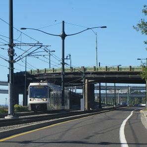 North Portland has a number of north-south thoroughfares, though the length of each one shortens as one moves from east to west due to the narrowing gap between the Columbia and Willamette Rivers. Only one major thoroughfare spans the entire length of North Portland, from its origin in the Lloyd District next to the Steel Bridge on up to the Interstate Bridge (which actually contains Interstate 5). Much has already been said about the MAX Light Rail line that runs along the street; a little less has been mentioned about the eventual extension of the line to Vancouver, WA that will create an actual interstate connection.
The name Interstate reflects the simple connection that Interstate Avenue has with Interstate 5. It runs 2 blocks west of the freeway for almost its entire length. Conveniently, drivers attempting to find I-5 in North Portland need only find Interstate to be close to the real thing, and they can even merge on to I-5 North from Interstate at Delta Park. The name Interstate obviously refers to the connection between Washington and Oregon, which is entirely governed by a north-south axis. In terms of transportation for the Portland-Vancouver area, that axis consists of the Burlington Northern Santa Fe Railroad, Interstate 5, Interstate 205 and the ships that cross the membranous Columbia.
Geographically, Interstate has more utility than just about any other street in North Portland, and much of that would be lost if the name of the street changed to a name that did not refer to the north-south characteristic of the street and its proximity to I-5. This is especially important because of North Portland’s eastern boundary is not very well defined for most Portlanders, and I-5 serves as a stand-in of sorts for N Williams Ave. The Boundary would bargain that a poll of most Portlanders would show that most think I-5 is the eastern boundary of North Portland, not the lesser-known N Williams Ave, even though the streets are 13 blocks apart. Changing the name of N Interstate Ave. to a non-geographic term could have the unintended effect of blurring the already tenuous North Portland boundaries.
Of course, utility is but one element of a sense of place. But in a city where diversity and tolerance promote divergent and distinct senses of place, on what can process ride besides utility? The current situation, which may lead the City to a decision that makes no one happy, can only run on plurality.
UPDATE: Blogtown PDX’s Amy Ruiz breaks the news that Mayor Potter has called for a public vote on the proposal to change the name of Interstate Ave. to César E. Chávez Boulevard.

 tend to his KXL radio program. Girod has also filed to run again, making it a rematch in the Santiam Valley for 2008.


Recent Comments